Entradas

Mostrando entradas de diciembre 24, 2017

Fortynine Palms Oasis Trail | Joshua Tree National Park, CA

Imagen
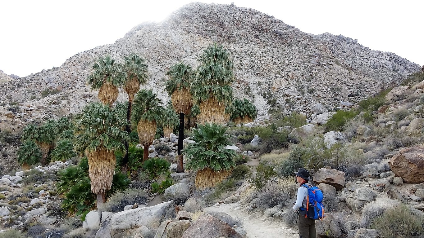
The Fortynine Palms Oasis Trail is a three-mile round-trip hike to a fan palm oasis located in the middle of nowhere. The oasis is located in the hills close to the northern Joshua Tree National Park boundary. Leaving from the parking area , the trail begins climbing up the mountain. The path heads uphill from the start on a well maintained single track. Each step increases the view of the surrounding desert. After winding around the ridgetop, the trail descends to the oasis. The trees were planted by miners to mark the spring that now irrigates the zone. The darkened trunks of the palms reflect the number of fires that have come through the area in recent history. 

Lost Horse Mine Trail | Joshua Tree National Park, CA

Imagen
In the late 1800s, miners dug around 300 mines in the lands now protected as Joshua Tree National Park . The Lost Horse Mine is one the best-preserved gold mines in the southwest area of the park. You can access by hiking a full 6.7 mile circular trail. This loop can be walked in either directions. From the trailhead , the path follows an old mine road until you reach a big wooden stamp mill . Currently, the mine is surrounded by a fence to protect visitors from the dangerous. Between 1894 and 1931, the mine produced 10,000 ounces of gold and 16,000 ounces of silver. Lost Horse Mine Lost Horse Mine Past the mine, the trail goes up and reach a mountain pass . On the right, you can see the highest point of the Lost Horse Mountain . Leave the main road and follow the indications to get the summit (5313 ft). By the way, don't forget your camera, the views are impressive. Summit of the Lost Horse Mountain Return to the mountain pass by the

Desert Bighorn Sheep | Joshua Tree National Park, CA

Imagen
The Desert Bighorn Sheep is a type of wild sheep that inhabit mountainous or rocky terrain areas. They live in the arid regions of the Southwest United States and Mexico . About 250  Desert Bighorn Sheep  live in the Joshua Tree National Park . 🐐 The sheep prefer a habitat of steep, rocky terrain for escape from predators. One of the best places to look for bighorns in Joshua Park is the  Barker Dam that serves as a water source for these animals. They can go for days without water. In fact, during particularly dry years, the sheep can get all the water just from plants such grass or cactus. Desert Bighorn Sheep  are gregarious animals, forming herds of 8-10 individuals. Male sheep , called rams , can be recognized by their massive brown horns. Horn size is a symbol of rank in the herd.

Stubbe Springs Loop Trail | Joshua Tree National Park, CA

Imagen
The best way to immerse yourself in the beauty of Joshua Tree National Park  is to head into the desert backcountry, and we did it. We chose the Stubbe Springs Loop Trail . It is a tough hike, but ideal for adventure seekers. During this hike you will find numerous types of terrain. ❗ Remember that it is a desert environment. Be sure to stay hydrated and bring First-Aid supplies. You have to bring all the water you’ll use on your trip. We started out from the Juniper Flats parking lot following the  California Riding and Hiking Trail . It is a well-defined route without much elevation gain. After walking for approximately 4 miles, we left the main road and took a path that connects with the Stubbe Springs Trail . This first portion is quite scenic and it has plenty of Joshua trees and interesting desert plants. 🌴🌵Joshua trees aren't really trees, they’re flowering yucca plants valued by the native Indians to make soap and baskets. Our steps took us to the high p

Arch Rock and Grand Tank reservoir | Joshua Tree National Park, CA

Imagen
The Arch Rock Trail is a short walk inside the Joshua Tree National Park , in southeastern California . The boulders in the area are examples of monzogranite : molten liquid pushed from the earth’s core, cooled by the rocks closer to the surface. Centuries of wind and erosion has transformed the rocks into interesting shapes. The path starts in the White Tank Campground near the Pinto Basin Road . It is a short, easy, and flat hike that takes you to the impressive 30-foot granite arch: the  Arch Rock . The route has interpretive signs along the way detailing rock formations and geology. The Arch is the most popular destination for visitors to White Tank.  You can access the top and walk carefully through the arch. Arch Rock Past the arch, our path continues towards the Grand Tank reservoir. Small cement dams were added to natural rock dams to create seasonal water catchment during rainstorms. The added dam create a water supply for livestock over the hot s